
Order Total (1 Item Items):
Shipping Destination:

Christophori Cellarii (34 results)
Skip to main search results
Product Type
- All Product Types
- Books (34)
- Magazines & Periodicals
- Comics
- Sheet Music
- Art, Prints & Posters
- Photographs
- Maps
- Manuscripts & Paper Collectibles
Condition
Binding
Collectible Attributes
Free Shipping
Seller Location
Seller Rating
-
Christophori Cellarii Compendium Antiquitatum Romanarum: Denuo In Usum Literatae Juventutis (1817) (Latin Edition)
Published by Kessinger Publishing, 2010
ISBN 10: 1160828970ISBN 13: 9781160828970
Book
Condition: New.
-
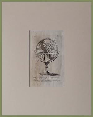
senza rilegatura. Condition: ottimo. Incisione originale in acciaio In Passepartout cm 30 x cm 36. Battuta cm 9 x cm 16 ca In Ottimo stato di conservazione. Globi chartae geographicae et sphaerae Tratta dall'opera del Cellarius : "Geographia Antiqua".
-
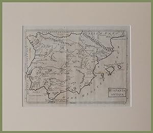
senza rilegatura. Condition: ottimo. Incisione originale in acciaio In Passepartout cm 30 x cm 36. Foglio cm 20 x cm 26 ca In Ottimo stato di conservazione. Hispania Antiqua Tratta dall'opera del Cellarius : "Geographia Antiqua".
-
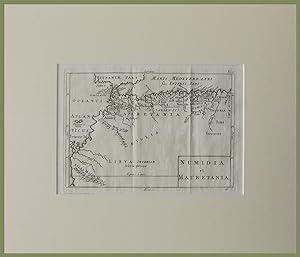
senza rilegatura. Condition: ottimo. Incisione originale in acciaio In Passepartout cm 30 x cm 36. Foglio cm 20 x cm 26 ca In Ottimo stato di conservazione. Numidia et Mauretania Tratta dall'opera del Cellarius : "Geographia Antiqua".
-
senza rilegatura. Condition: ottimo. Incisione originale in acciaio In Passepartout cm 30 x cm 36. Foglio cm 20 x cm 27 ca In Ottimo stato di conservazione. Asia cis Taurum Tratta dall'opera del Cellarius : "Geographia Antiqua".
-
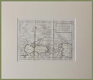
senza rilegatura. Condition: ottimo. Incisione originale in acciaio In Passepartout cm 30 x cm 36. Foglio cm 20 x cm 26 ca In Ottimo stato di conservazione. Colchi's Iberia Albania Sarmatia Tratta dall'opera del Cellarius : "Geographia Antiqua".
-
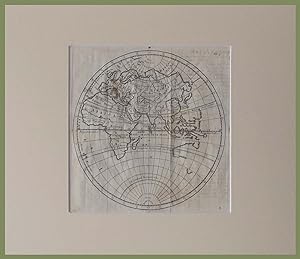
senza rilegatura. Condition: ottimo. Incisione originale in acciaio In Passepartout cm 30 x cm 36. Foglio cm 20 x cm 27 ca In Ottimo stato di conservazione. Planisfero Europa Asia Africa Tratta dall'opera del Cellarius : "Geographia Antiqua".
-
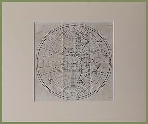
senza rilegatura. Condition: ottimo. Incisione originale in acciaio In Passepartout cm 30 x cm 36. Foglio cm 20 x cm 26 ca In Ottimo stato di conservazione. Planisfero America Tratta dall'opera del Cellarius : "Geographia Antiqua".
-
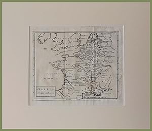
senza rilegatura. Condition: ottimo. Incisione originale in acciaio In Passepartout cm 30 x cm 36. Foglio cm 20 x cm 26 ca In Ottimo stato di conservazione. Gallia Antiqua Transalpina Tratta dall'opera del Cellarius : "Geographia Antiqua".
-
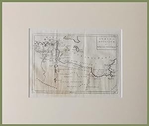
senza rilegatura. Condition: ottimo. Incisione originale in acciaio In Passepartout cm 30 x cm 36. Foglio cm 20 x cm 26 ca In Ottimo stato di conservazione. Syrtes Byzacium et Africa Propria Tratta dall'opera del Cellarius : "Geographia Antiqua".
-
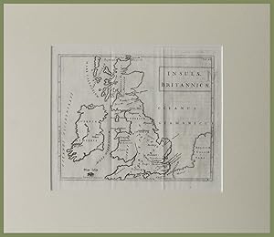
senza rilegatura. Condition: ottimo. Incisione originale in acciaio In Passepartout cm 30 x cm 36. Foglio cm 20 x cm 26 ca In Ottimo stato di conservazione. Insulae Britannicae Tratta dall'opera del Cellarius : "Geographia Antiqua".
-
senza rilegatura. Condition: ottimo. Incisione originale in acciaio In Passepartout cm 30 x cm 36. Foglio cm 20 x cm 26 ca In Ottimo stato di conservazione. Aegypti Delta et Nili Ostia Tratta dall'opera del Cellarius : "Geographia Antiqua".
-
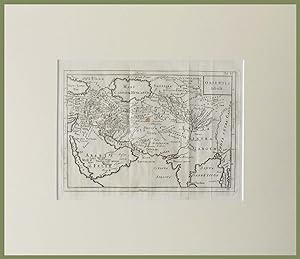
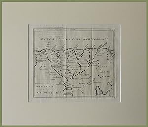
senza rilegatura. Condition: ottimo. Incisione originale in acciaio In Passepartout cm 30 x cm 36. Foglio cm 20 x cm 27 ca In Ottimo stato di conservazione. Orientis Tabula Tratta dall'opera del Cellarius : "Geographia Antiqua".
-
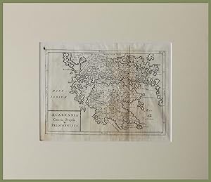
senza rilegatura. Condition: ottimo. Incisione originale in acciaio In Passepartout cm 30 x cm 36. Foglio cm 20 x cm 26 ca In Ottimo stato di conservazione. Acarnania Graecia Propria et Peloponnesus Tratta dall'opera del Cellarius : "Geographia Antiqua".
-
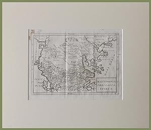
senza rilegatura. Condition: ottimo. Incisione originale in acciaio In Passepartout cm 30 x cm 36. Foglio cm 20 x cm 26 ca In Ottimo stato di conservazione. Macedonia Thessalia Epirus Tratta dall'opera del Cellarius : "Geographia Antiqua".
-
Geographia Antiqua. Recognita denuo, & ad veterum novorumque scriptorum fidem, historicorum maxime, identidem castigata.
Published by F.C. & J. Rivington London, 1816
Book
Condition: Gut. Editio nova et castigatior. 180 S. Mit einigen s/w-Karten bzw. Illustrationen, zum gr��ten Teil ausklappbar. Die Karten Nummer 2, 3, 5, 6 und 7 (von 27) scheinen nach der Nummerierung zu fehlen. Neu in Pappband gebunden. Einband leicht berieben und leicht lichtrandig. Kanten leicht besto�en. Schnitt nachgedunkelt. Sonst ordentlich. Sprache: Deutsch Gewicht in Gramm: 384 Pappband (nachgebunden, ca. 1970er / 1980er Jahre) 21,6cm x 13,6cm.
-
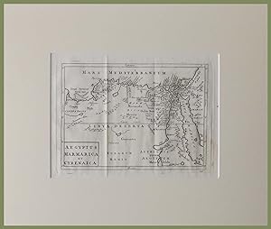
senza rilegatura. Condition: ottimo. Incisione originale in acciaio In Passepartout cm 30 x cm 36. Foglio cm 20 x cm 26 ca In Ottimo stato di conservazione. Aegyptus Marmarica et Cyrenaica Tratta dall'opera del Cellarius : "Geographia Antiqua".
-
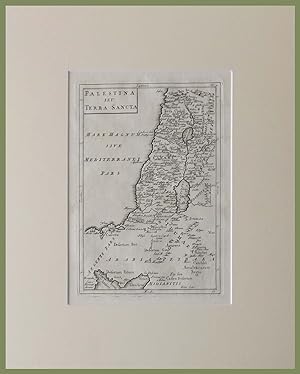
senza rilegatura. Condition: ottimo. Incisione originale in acciaio In Passepartout cm 30 x cm 36. Foglio cm 20 x cm 26 ca In Ottimo stato di conservazione. Palestina seu Terra Sancta Tratta dall'opera del Cellarius : "Geographia Antiqua".
-
Geographia antiqua in compendium redacta
Published by Regione Piemonte, 2007
ISBN 10: 8882621227ISBN 13: 9788882621223
Book
Condition: Buone. italiano Condizioni dell'esterno: sovracopertina strappata Condizioni dell'interno: Buone.
More buying choices from other sellers on AbeBooks
Used offers from US$ 51.07
Also find Hardcover First Edition
-

ORTHOGRAPHIA LATINA EX VETUSTIS MONUMENTIS HOC EST NUMMIS, MARMORIBUS, TABULIS, MEMBRANIS, VETERUMQUE GRAMMATICORUM PLACITIS.
Published by casa editrice: APUD JOSEPHUM COMINUM anno: 1763 citta': PATAVII (PADOVA), 1763
LEGATURA COEVA IN PIENA PERGAMENA, PICCOLA INCISIONE AL FRONTESPIZIO E PICCOLO BOLLO DI PROPRIETA' numero pagine: 116 formato: 17.7X11.6 stato conservazione: ABBASTANZA BUONO, RISVOLTI CON PICCOLE MANCANZE E PIEGHE edizione: EDITIO III PATAVINA.
-
Breviarium Antinquaritatum Romanarum Accurante Hieronymo Freyero
Published by ex Typographia Regia, 1742
Hardcover. Condition: Good. No jacket. In Latin. Octavo. Vellum binding. Shelfworn, with foxing and staining throughout.
-
C. Julii Caesaris itemque Auli Hirtii quae extant omnia.
Published by Ex Off. Annesii de Nobilibus., Bononiae., 1828
2 tomi in 1 vol., in 16�, cart. muta., pp. 348 + 193. Piatti marmorizzati.
-
BREVIARIUM ANTIQUITATUM ROMANARUM ACCURANTE HIERONYMO FREYERO.
Published by Typ. Regia. Augustae Taurinorum (Torino), 1742, 1742
Seller: Libreria Anticuaria Farr�, Barcelona, BARCE, Spain
Seller Rating:

. 18 cm. 1 h., XII-191 p�g. Enc. en pasta espa�ola, cortes pintados. Lomo fatigado con perdida en la parte superior. Historia antigua. Roma.
-
Christophori Cellarii Smalcaldensis Geographia Antiqua : Recognita denuo, & ad veterum novorumque scriptorum fidem, historicorum maxime, identidem castigata, & Quinta Editione plurimis locis aucta & immutata.
Published by Sumptibus S. Ballard, M. Senex, G. Innys, T. Longman, 1755
Book
Hardcover. Condition: Fair. No Jacket. 8vo leather bound volume. Front board almost off back ok. Early ink signature and early ink doodling to back end papers. Contents clean and unfoxed but sadly missing 3 maps. Eastern hemisphere, Hispania and Africa. 23 foldout maps present.
-
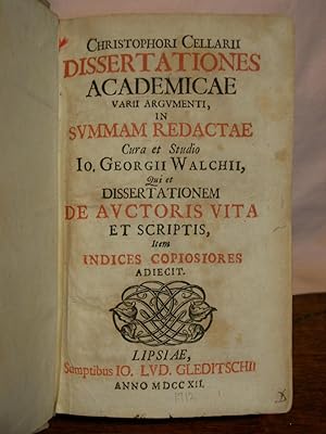
DISSERTATIONES ACADEMIC� UARII ARGUMENTI, IN SUMMAN REDACT� CURA ET STUDIO IO. GEORGII WALCHII, QUI ET DISSERTATIONEM DE AUCTORIS VITA ET SCRIPTIS, ITEM INDICES COPIOSIORES ADIECIT
Published by Sumptibus Io. Lvd. Gleditschii, Lipsl� [Leipzig], 1712
Seller: Robert Gavora, Fine & Rare Books, ABAA, Talent, OR, U.S.A.
Association Member: ABAA CBA ILAB
Seller Rating:
Hardcover. Religious dissertaions about Christianity and religion. 860 pages plus eighteen page index. Bound in contemporary full velum. Vellum soiled with title on the spine barely visible. Pages moderately toned but does not affect the readability. Hinges solid and binding firm. An almost very good copy. Book.
-
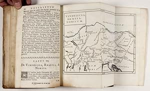
Smalcaldensis Geographia antiqua recognita denuo, & ad veterum novorumque scriptorum fidem, historicorum maxime, identidem castigata, & quinta editione plurimis locis aucta & immutata. Huic demum sext� editioni tot chartas ex majori auctoris Geographia antiqua, quot ad minorem hanc illustrandam requirebantur, duplicemque indicem, quorum priori vetera locorum nomina novis pr�ponuntur, posteriori nova veteribus
Published by S. Ballard, J. Senex, G. Innys, J. Osborn and T. Longman, London, 1731
Seller: ERIC CHAIM KLINE, BOOKSELLER (ABAA ILAB), Santa Monica, CA, U.S.A.
Seller Rating:
Hardcover. Condition: poor to vg. Sixth Edition. 8vo. viii, 180pp. plus 27 fold out maps. Brown blind-stamped calf. Title page printed in red and black. A Latin geography book designed as an aid to the study of the Old and New Testament by the 17th century German scholar Christoph Cellarius (Keller), a pioneer in the study of medieval geography. Includes an introduction by Samuel Patrick, who, in the 18th century, rescued the "Geographia" and used it as a textbook for English school children. Maps include the world, the Middle East, Germany in antiquity, Spain in antiquity, Palestine, Greece and Latium. This work exemplifies the scientific trend in Enlightenment era Protestant thought. A period in which clergymen played leading roles in the advancement of science as they sought evidence to confirm the biblical narrative. Decorative initials and head and tail pieces. Text in Latin. Signed by previous owner on front free endpaper, same leaf almost detached but still holding. Age wear and abrasions on binding. Binding copy with front board detached, but present. Outline of Italy drawn on fly leaf. Lower left corner of the world map chipped (not affecting the illustration). Map of Spain hand-colored, with parts of other fold out maps outlined in color. Binding in overall poor to fair, interior in good+ to very good condition. References: Walter A. Goffart, "Historical Atlases: The First Three Hundred Years, 1570-1870" pg. 140 and 231-33.
-
SMALCALDENSIS GEOGRAPHIA ANTIQUA RECONGNITA DENUO, & AD VETERUM NOVORUMQUE FCRIPTORUM FIDEM, HISTRICORUM MAXIME, IDENTIDEM CASTIGATA & QUINTA EDITIONE PLURIMIS LOCIS AUCTA & IMMUTATA, HUIC DEMUM FEXAE EDITIONI TOT CHARTAS EX MAJORI AUCTORIS GEOGRAHIA ANTIQUA QUOT AD MINOREM BANC ILLUSTRANDAM REQUIREBANTUR, DUPICEMIQUE INDICEM QUORUM.
Published by S & E Ballard, et al, Ldn, 1755
First Edition
Hardcover. Condition: Very Good. 1st Edition. 180 pp.+ 27 FoldOut Maps, Full Drk Brn Leather Hardback, Dble Gilt Lines around Covers & Rules along Ridges on Spine, hinges reinforced else VG, 1st ed (The Maps are on High Quality Paper and are Pristine & Crisp. Except for a couple world View Maps, most are from around the Mediterranean but extend to the Middle East, Northern Europe & Saharan Africa. Most surrounding countries are represented. Many of the Maps could be beautifully framed).
-
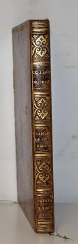
Christophori Cellarii Orthographia Latina ex Vestustis Monumentis Hoc est Nummis, Marmoribus, Tabulis, Membranis, Veterumque Grammaticorum placitis; Nec Non Recentium ingeniorum curis excerpta, digesta, novisque observationibus illustrata. Suivi de: De Principiis Rerum ad Paulum III. Suivi de De immortalitate Animorum.
Published by Patavii, Josephum Cominum, 1763 & 1751., 1763
Trois textes r�unis en un volume in-8 de 116 & 125 pages et 1 feuillet de catalogue. Provenance: abb� Robert Merlette. Basane marbr�e du XIX�me si�cle, roulette dor�e sur les plats, dos plat orn�, bon �tat. Christophorus Cellarius (latinisation de Christoph Martin Keller), n� en 1638 � Schmalkalden et mort en 1707 � Halle, est un philologue et �rudit allemand. Scipio Capicius, en fran�ais Scipion Capece (en italien Scipione Capece), (n� � Naples, 1480 - mort v. 1551) �tait un juriste et po�te n�olatin du XVIe si�cle. Aonio Paleario (c. 1500 - 3 juillet 1570) �tait un chr�tien r�formateur italien. Membre de la Soci�t� historique de Compi�gne (en 2009), l'abb� Bernard Merlette, �rudit bien connu des m�di�vistes, notamment pour ses travaux sur les �coles et les biblioth�ques de Laon, mais �galement pour son intime connaissance des manuscrits m�di�vaux et l'aide pr�cieuse qu'il a toujours bien voulu apporter aux chercheurs, a aussi, durant plusieurs d�cennies, rassembl� une importante biblioth�que de recherche, au gr� d'une fr�quentation assidue des libraires et bouquinistes parisiens.
-
[Geographia Antiqua] Christophori Cellarii Smalcaldensis Geographia Antiqua - Recognita denuo & ad veterum novorumque scriptorum fidem, historicorum maxime, identidem castigata & Quinta Editione plurimis locis aucta & immutata. Huic demum sext� Editioni Tot Chartas ex majori auctoris Geographia antiqua quot ad minorem hanc illustrandam requirebantur, Duplicemque Indicem, Quorum Priori vetera locorum nomina novis pr�ponuntur, Posteriori nova veteribus, Addidit, totam recensuit, & Scholarum usui accommodavit, Samuel Patrick.
Published by London, Sumptibus S. Ballard, J. Senex, G. Innys, J.Osborn & T. Longman., 1731
Book
[Sixth Edition and the first illustrated version]. Octavo. VIII, 180 pages with 26 maps and one scientific illustration of a Globe [sphere]: Globi, Charta Geographicae et Sphaerae a Joannes Senex (Fol.2). Original Hardcover / 18th century full leather with the original spine-label. The Volume in protective Mylar. The binding starting at the spine but still firm and entirely in its original condition. Very good overall condition with only minor signs of wear. From the library of Daniel Conner (Connerville / Manch House), with his Exlibris / Bookplate to pastedown. With a manuscript - entry to the rear endpaper: "Dan [meaning Daniel Conner] began Astronomy April 19th 1812". This important biblical Geography [Atlas] included maps for the first time in the here offered sixth edition [see reference by Rodney W. Shirley]. The Volume includes the following Maps and Illustrations: 1. Joannes Senex - [Globe] Globi, Chartae Geographiae et Spaerae optimi [the illustration of the Sphere is placed in this edition according to the bookbinders outlining behind page 2 [Fol.2], some editions have it bound as Frontispiece] 2. Europa, Asia & Africa (Double-page map) 3. America (Double-page map) 4. Hispania Antiqua (Double-page map of Historical Spain, folding out on two sides) 5. Gallia antiqua transalpina (Double-page map of France with parts of Germany) 6. Britannicae insulae (Double-page map of England, Scotland (Caledonium) and Ireland (Ivernia - Hibernia) 7. Germania antiqua (Double-page map of Historical Germany) 8. Vindelicia, Rhaetia, Noricum (Double-page map showing from Venice (Veneti), Brigantium and the Region south of the Danube) 9. Pannonia, Moesia, Illyricum & Thracia (Double-page map of the Roman provinces) 10. Cisalpina Gallia, Italiae antiquae pars (Double-page map of northern Italy and adjacent regions, extending from Venice on the Maris Adriatici, to Pisa and Nice (Nicaea) on the Mediterranean, to Lake Geneva in the west, and the Alps in the North) 11. Italia propria (Double-page map of central Italy, focusing on Rome and adjacent provinces) 12. Latium (Double-page map of a magnified Rome and surroundings) 13. Magna Graecia - Italiae antiquae pars (Double-page map showing southern Italy with an inset map "Sinus Baianus et Puteolanus") 14. Sicilia Antiqua (Double-page map of Sicily with an inset) 15. Macedonia, Thessalia, Epirus (Double-page map) 16. Acarnania, Graecia Propria & Peloponnesus (Double-page map) 17. Insulae Graeciae & Creta with Corsica et Sardinia (Double-page map) 18. Asia cis Taurum (Double-page map of ancient Turkey with Cyprus) 19. Orientis tabula (Double-page map of Arabia Felix Arachosia etc. with Mare Caspium, Syria, Armenia Maior, Persia ) 20. Colchis, Iberia, Albania & Sarmatia (Double-page map) 21. Syria, Coelesyria, Phoeniciae & Mesopotamia (Double-page map) 22. Palaestina seu Terra Sancta (Double-page map of ancient Palestine) 23. Aegypti Delta et Nili Ostia (Double-page map of ancient Egypt with Memphis, Nomos etc.) 24. Aegyptus, Marmarica et Cyrenaica (Double-page map of Egypt and neighbouring regions to the West) 25. Syrtes, Byzacium et Africa Propria (Double-page map of ancient Libya and modern Tunisia) 26. Numidia et Mauretania (Double-page map of the ancient Maghreb (present-day Algeria and Morocco with Atlas Mountains and Berber Regions) 27. Africa Interior (Double-page map with Ethiopia Inferior) Sprache: latin.

![Seller image for [Geographia Antiqua] Christophori Cellarii Smalcaldensis Geographia Antiqua - Recognita denuo & ad veterum novorumque scriptorum fidem, historicorum maxime, identidem castigata & Quinta Editione plurimis locis aucta & immutata. Huic demum sext� Editioni Tot Chartas ex majori auctoris Geographia antiqua quot ad minorem hanc illustrandam requirebantur, Duplicemque Indicem, Quorum Priori vetera locorum nomina novis pr�ponuntur, Posteriori nova veteribus, Addidit, totam recensuit, & Scholarum usui accommodavit, Samuel Patrick. for sale by Inanna Rare Books Ltd.](https://pictures.abebooks.com/inventory/md/md31493519924.jpg)